The Advanced Weather Interactive Processing System, A Critical Review
The Advanced Weather Interactive Processing System, or AWIPS logo. Image courtesy, http://www.weather.gov/.
The Advanced Weather Interactive Processing System, or AWIPS is an operating system, (OS) for a computer like the Windows series. Though this is not a public operating system. AWIPS was designed by the government for the National Weather Service. AWIPS has all of the capabilities of the National Weather Service, and makes most of what a local Weather Forecast Office (WFO) possible. There are many great advantages of AWIPS. Such as the overlaying of many data streams from many weather models, radar, and sattelite data from the Geostationary Operational Environmental Sattelites (GOES). There is also access to make every forecast made by the WFO and upper-air skew-t maps. Though these programs make AWIPS the best meteorological system ever designed in my opinion, there are drawbacks. AWIPS cannot display its data in a three-dimensional environment. There is also no access to model skew-t charts, which makes the Bufkit program that I have mentioned in pressure-gradient windstorms necesssary for the National Weather Service. Though AWIPS is still the standard today, there is another model of AWIPS being released from the government. The Aply named, AWIPS 2! Hopefully it will improve on what the original AWIPS has already started. |

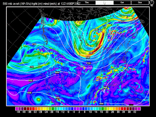
An upper-air map from the North American Model or NAM. Images such as these are easily available and understandable to forecasters with AWIPS. Image Courtesy: www. weatherunderground.com

No comments:
Post a Comment